
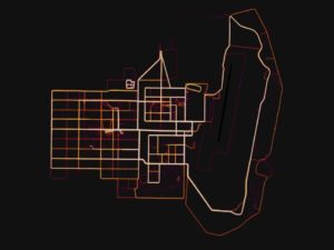
A GPS Strava heat map of a military base in the Helmand province of Afghanistan ( Strava/Mapbox )
“Effective immediately, Defense Department personnel are prohibited from using geolocation features and functionality on government and non-government-issued devices, applications and services while in locations designated as operational areas. It goes back to making sure we’re not giving the enemy an unfair advantage and we’re not showcasing the exact location of our troops worldwide.This is all electronic devices that have geolocating features, basically GPS enabled devices, applications, that type of thing,” Pentagon spokesman Col. Rob Manning, Monday 6th Aug 2018.
The restrictions were issued some six months after the location and movements of U.S. troops were included in a usage map published by the Strava fitness tracking company. The global map reflected more than 1 billion paths that the Strava app tracked — but patterns and locations of U.S. service members could be gleaned from zooming in on sensitive or secured areas.
“These geolocation capabilities can expose personal information, locations, routines, and numbers of DoD personnel,” Deputy Defense Secretary Shanahan wrote in a message to service chiefs, “and potentially create unintended security consequences and increased risk to the joint force and mission.”
Of course, the irony of this is the fact that the DoD was behind the development of the GPS satellite system that provided it with all the necessary data to deploy the latest generations of highly accurate and autonomous weapon systems. Now, the aim is to develop a strategy to minimise the risk of using such applications and software, while at the same time not completely remove their use by military personnel where OPSEC is not compromised and/or where the data made available to other web-users is not critical; this should be ready sometime in early September.
None of this will come as a big surprise as there have been a number of reports about the amount of useful intel being posted on the internet by “sharing apps”. In January this year UK papers were carrying reports of these breaches of security around bases in Afghanistan. It was also a factor in the inquiry into the disappearance of RAF Gunner Corri McKeague whose phone data was used to track its (and possibly his), last known movements, leading to the detailed examination of the Milton landfill site in Cambridgeshire in late 2017
Strava, the main reason for the current concern, was very open about the level of detail its system can provide. It allows people to track others engaged in a range of sports activities, or merely walking around. However, it does allow users to opt out of sharing their data - something that the US DOD has emphasised its personnel should do as an IA response to the recent alarm. Strava released what it calls a Global Heatmap. It shows accumulated data for many areas which might allow someone to make an assessment about the value of a potential attack or ambush on a site which they thought was used by military personnel.
Strava issued a statement saying:
“Our global heatmap represents an aggregated and anonymised view of over a billion activities uploaded to our platform. It excludes activities that have been marked as private and user-defined privacy zones. We are committed to helping people better understand our settings to give them control over what they share.”
The UK MOD’s DCCS
In a related story, the UK MOD is trying to develop a system that will address the inherently unreliable nature of GPS-based locators when used in built-up areas or under cover. Its Dismounted Close Combat Sensors (DCCS) system will make it possible to track troops without GPS, while providing better situational awareness. DCCS is a modular, multiple open-source system that conforms to the MoD’s Generic Soldier Architecture which is intended to bring some standardisation to equipment requirements. It’s based on a core of GPS, Inertial Navigation System (INS), and video-tracking sensors that include lasers, dual-antenna GPS, a new thermal sight, a shortwave infrared band for targeting, and integrated magnetic sensors. For navigation, DCCS uses INS sensors and a compass to provide a soldier’s location, based on speed and bearings from the last known GPS fix. Visual cues, such as doors, windows, etc. will allow allow the system to calculate the individual’s position even in three dimensions.
Comments on GPS-based tracking apps banned for US personnel